
Greenland crossing: food for ultimate Arctic adventure
Food and drinking for Greenland Crossing adventure: a diet for 35 days expedition in Arctic.
Main Beskid Trail – the longest mountain trail in Poland. With 500 kilometers it’s the longest marked trail, one can thru-hike in Polish mountains. For some, it’s a ticket to longer long-distance trails abroad. For many others – a challenge to face and the longest distance of their lives. It crosses the main ranges of the Polish Carpathian Mountains, passing major summits, often near Poland’s southern border. It climbs many important peaks, including Babia Góra (Babia Mountain), our highest peak outside the Tatra Mountains. This thru-hike is honorable challenge for many Polish tourists.
Each year dozens (probably hundrets) of people start their MBT thru-hike.
I thru-hiked my MBT in late summer 2016. My plan that time was to connect all Beskidy and Sudety Mountains during one push – thus cross our entire southern border. That year I’ve walked slower then expected and I’ve decided to skip the Sudety Mts. Finally, I ended up with only the Main Beskidy Trail. Although I was quite familiar with most of it from years of section hiking, that year, at last, I’ve put it all together.
I had no intention of describing every hour on the trail. This article, therefore, is not an account of the MBT thru-hike. Instead, I want to answer the question: how to thru-hike Main Beskid Trail? How to plan your hike, accommodation, daily sections, supplies? What to pay attention to and what difficulties to prepare for?
The Main Beskid Trail is Poland’s longest marked trail. A 500 km walk might be just fun for someone, who already made some long-distance trails in USA or rest of Europe. It will never be an “easy” thing however, for someone who has hiked on shorter paths. Such a distance puts a significant strain on your body and can be a “shock” for someone unfamiliar. A long distance walking can cause minor foot injuries (blisters, abrasions) or major injuries (from minor sprains to stress fractures). Although the possibility of a serious accident on the MBT is unlikely, it is a good idea to test yourself on shorter trails before starting this walk. During the hike itself, it is also worth to walk with gentle pace, at least until you feel comfortable with your daily mileage. Some bigger ascents await on many parts of the MBT, even in the seemingly easy Beskid Niski range. You will laso meet some steep descents, so proper shoe cushioning and trekking poles are important. However, there are no scrambling/climbing moments on the trail.
Much of the Main Beskidy Trail are forest paths and meadows. In most of sections, during rough weather, a walker can quite easily find cover from strong winds. Only the highest parts of the trail offer no protection from the elements. These are: the massif of Halicz and Tarnica, Połonina Caryńska and Połonina Wetlinska (all of them in Bieszczady Mountainns, eastern end of the trail) and Babia Góra (Beskid Żywiecki range). When planning a hiking day on any of these sections, be sure to check the weather forecast.
Although public transportation in many parts of Poland is infrequent, getting to the start of the trail should not be a hassle, especially during the summer season. Transportation to Ustroń (western terminus) is provided by buses from Bielsko-Biała and Cieszyn, and the start of the trail is in the center of the village. Getting to Wołosate is more of a problem. Single buses from Sanok and Ustrzyki Dolne reach small village of Ustrzyki Górne close to Slovak/Ukrainian/Polish border meeting point. Fr5om there you have 5 km along asphalt road to Wolosate and eastern terminus of the MBT. A trip to the east of the Bieszczady Mountains means some changing from between buses and/or trains and waiting, but shouldn’t be dramatic.
If you are looking for connections between any two point of our country, e-podroznik website and app will be the best.
The entire Main Beskidy Trail is perfectly covered with tourist maps. For 15+ years I prefer Compass maps – they are very clear, have very little of inaccuracies and are printed at a convenient scale of 1:50,000. This is important when you want to quickly assess the distance – 1 cm on the map is 500 m in the field. To cover the entire trail, you need 6 sheets. Each of them corresponds to the massifs you are passing through: Bieszczady, Beskid Niski, Beskid Sadecki, Gorce, Beskid Żywiecki with Orawsko-Jordanowskie Highland and Beskid Śląski. The total cost of such a set is about 20 EUR. The disadvantage? In addition to the trail and its surroundings, the maps cover large areas beyond your interest. On the other hand – let’s be honest, 6 sheets of paper do not weigh much.
A cheaper option is the guide “Main Beskid Trail” by Agata Hanula, published by Compass or “Main Beskidy Trail. MountainBook” by Krzysztof Bzowski and the “Bezdroża” publishing house. Aditional information in Polish won’t be of any use to you, but they include a set of MBT maps. The advantage of this solution? As your march progresses, you can tear out more pages, relieving your luggage (a variant for the desperate hikers).
The easiest option for navigation, are simple and free apps for smartphones. There is terrific and free “Mapa Turystyczna” website and mobile app for Android and Apple. You can also use very fine Mapy.cz website and its Android app or Apple app.

In Poland, hiking trails are marked with two horizontal white stripes and a colored stripe between them. A white circle containing a colored circle in the center indicates either the beginning or end of a trail. Many people mistakenly believe that the color represents the difficulty level of the hiking trail, but this is not true. The color coding is used to show the importance and length. Red ones should be the longest and most important main hiking trail in the area, but it’s not always the rule. The Main Beskid Trail is marked along its entire length with two horizontal white stripes and a red stripe between.
Although it is the most important route of the Polish Beskidy Mountains, the quality of marking varies.
Usually the sections running through national parks are well marked. I also have no objections to the central and western parts of the trail (there are only tiny exceptions). However, there are places that require impovements. This applies primarily to the eastern Beskid Niski, in the Tokarnia Mountain and its surroundings. Sometimes the trail might be lacking marks and their absence is particularly frustrating in places that need them: at intersections, turns and crossroads. It happens that the unpainted path loses its red stripes precisely at such points. This forces you to search for the right path for a moment. But in general it’s vell visible to the point, where it’s often possible to hike without a map.

Should you take a map and compass? Definitely yes. However, it can easily be an app, not a paper.
Is a GPS necessary? Definitely no. A paper map is perfectly sufficient, unless you intend to record the trace of your hike. Except in extreme situations (winter, huge cloud cover and fog), satellite navigation is unnecessary. However, if you think you need GPS support or want to carefully plan your route, you can find the route of the Main Beskid Trail in GPX format at this link – you can open it in Google Earth and trace the course of the trail on computer before headong off. You can also send it to your GPS watch any app you prefer. Main Beskidy Trail can also be found at WaymarkedTrails.org website.
The Main Beskid Trail is 6 mountain ranges and 1 foothills of variable character.
The first 50% of MBT (when hiking from the east) are Bieszczady and Beskid Niski. These mountain ranges are my favorites ones. The high parts of Bieszczady, located closer to Ukrainian border, is a fantastica and scenic beginning of adventure, though not necessarily easy.

In Bieszczady Mountains, the trail rarely descends to the villages, so you’ll have full-day sections through the subalpine zone and mounain pine and beech forests. After first day of walk you’ll stop at Ustrzyki Górne village. Another 2 days will lead you tovillage of Cisna. After approximately 4 days you should reach Komańcza and river Oslawa valley – the border of Bieszczady range.

Beyond the Oslawa valley, in the Beskid Niski, all the way to Rymanow, it’s a march in fairly wild mountains. The eastern Beskid Niski is also the poorest marked section of the Main Beskidy Trails (but still decend one). Beskid Niski will take you 5-6 day, depending on your pace. It’s the biggest mountain range in Poland in terms of area. Beskid Niski is sometimes considered the wildest mountain range in Poland, and its distinctive feature is the picturesque valleys of non-existent villages.

In the central part of the Beskid Niski, the trail pass several villages, following the main peaks: Cergowa, Hyrowa, Magura Wątkowska. This is also the section where you should plan your supplies well, because your camping spot may be few hours from the nearest village. The place is wild, green – but technically easy, with only a few steeper sections. In western part of Beskid Niski, beyond Wołowiec village, the trail crosses the massif of the Hańczowskie Mountains, several large ascents and descents, with the massif of the Kozie Żebro (Goat’s Rib) being the hardest. Between the ridges it crosses several small villages, lying close to each other (Ropki, Mochnaczka). The end of this part is the descent to big mountain town and resort, Krynica Zdrój.
Here the character of the MBT changes radically. Overgrown paths and empty valleys disappear. Their place is taken by wide and frequented trails, where you will regularly meet people. You will start to climb into Beskid Sądecki range. A few hours west from Krynica, you’ll pass a nice and cozy mountain shelter of Hala Łabowska. This place marks nearly exactly half of the MBT. When geting there, give yourself time for a short celebration: halfway is behind you!
Beskid Sadecki means also the first big ascents. Just 1 day later you will experience them, during the 4-hour approach from the River Poprad valley towards Wielki Rogacz and Radziejowa. This part, done in the afternoon heat, has remained in my memory as the most “wringing” place of all MBT. It is also one of four major ascents on the Main Beskid Trail. The others will be: Lubań in Gorce Mountains, Babia Góra in Beskid Żywiecki range and Barania Góra in Beskid Śląski range.
Beyond Radziejowa starts to descend for a long time, heading to Krościenko town (good resuply point!). Immediately after it climbs quickly to the top of Lubań in Gorce range. The main Gorce Mts. spine, between Lubań and Turbacz is one of my favorite places in Polish mountains, in terms of beauty – a nice trail winds along, with exceptional views of the surrounding massifs, including the Tatra Mountains.

After leaving Gorce Mountains, the section requires patience a little patience. It’s a passage through the Rabka town area, and crossing og unattractive S-7 express road, recently undergoing complete reconstruction. The red marks will take you towards Jordanów (here the trail might me poorly marked, too) with confusing passage across small Skawa river.
The landscape change briefly, however, with entering Mt. Polica Range and a lovely ascent to Babia Góra (Babia Mountain). It is the highest peak of the Main Beskid Trail and the only one, that gives you the illusion of being in the high mountains, similar to the Tatras. It’s also the moment for another celebration: although you have reached a modest 1,725 meters, you are at the highest point! After Babia Góra, you’ll have a few more hours to reach the Przełęcz Glinne (Glinne Pass) from where the path will take you towards mountain of Pilsko.

In my opinion, somewhere here the beauty of the MBT begins to fade. Few hours later, when passing Rysianka mountain shelter (another lovel;y hut, worth staying), I felt “, well, it’s over” moment in my head. From there a long and unpleasant rocky path will guide you to Węgierska Górka village, and from here the mountains starts to be civilized – more densely inhabited , devoid of wildness, and their forests destroyed by the mismanagement of the past 2 centuries.

The next section will take you through the slopes, coverd with dead, fallen trees, to Barania Góra. This important massif is the site of the source of the Vistula, the longest river in Poland. From Barania Góra you’ll descend along the valley, passing some villages and enter Beskid Śląski range – the last on your way. It’ll take about 1 day to pass two distinctive mountains: Stożek and Czantoria, already on the border with Czech Republic.
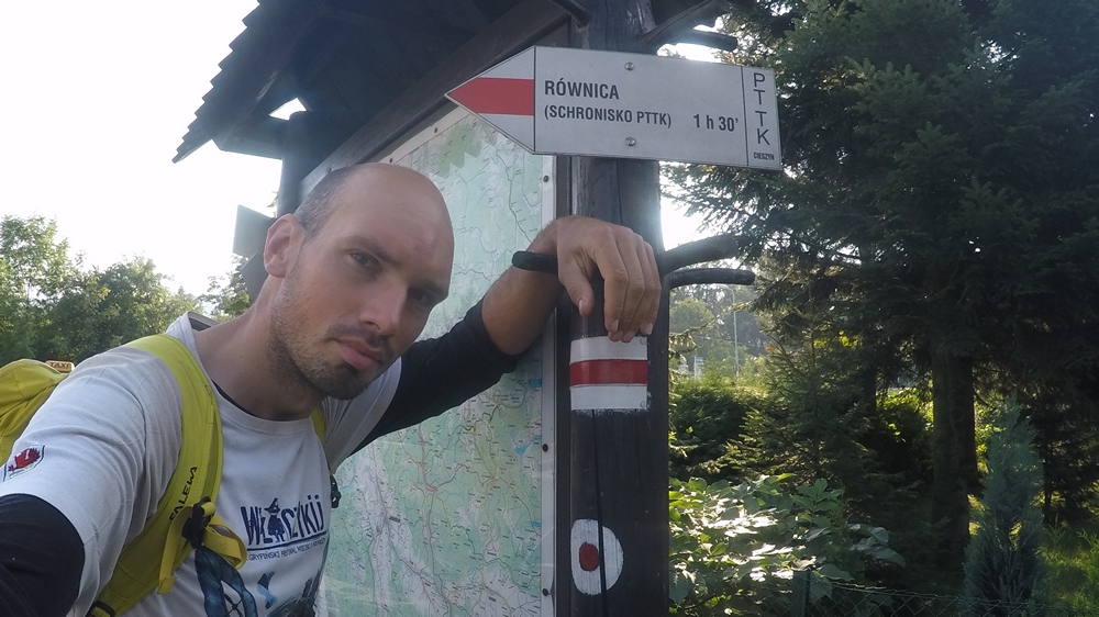
You last effort is the small but gnarly, lonely Mt. Równica – when it seems, that after a very steep descent from Czantoria your legs are about to give up, and your goal is already reached, the MBT forces you to climb an additional few hundred meters up and descend immediately. It’s a real test of perseverance when you know the finish line is 2 km away, and you still have almost 400 m up and down.
Eventually the trail goes down to the center of Ustroń town and there, next to the train station, you can finmally tap the red dot on the post, marking western the terminus of MBT. On the signpost there is no information, that this is the begining/end of the most important trail of Polish mountains.
The Main Beskidy Trail crosses 4 national parks and numerous nature reserves. Remember, that in Poland you are not allowed to camp overnight in national parks (wxcept some designated places, which are very rare). Aside from restrictions on stays there, these are the only places where an entrance fee is charged. You’ll need to buy a ticket on the entrance to Bieszczady National Park (in Wołosate and Ustrzyki Górne villages ) and Babiogórski National Park (at the entrance from Przełecz Krowiarki/Krowiarki Pass). There is no fee collection in Magurski NP and Gorczański NP, but you may notice boards at the entrance, that’ll ask you to buy tickets on-line.
Please, be warned that you are not allow to take dogs into those national parks, so dog-trekking along whole MBT is not technically possible.
Since 2021, the State Forests, in cooperation with the bushcraft communities, introduced new rules for overnight staying in the forests. Since that time, a “camping-allowed area” has been designated in each forest district operating in Poland. There are total of 475 areas available for overnight camping in our forests, where camping is fully legal. This will give access to camping sites for people around the the country. A map of the areas can be found in two locations:

Click on “Zanocuj w lesie” and the map will display the areas of interest in purple.
Overnight camping of up to 9 people for no more than two nights in a row does not require any notification. Longer camping in the forest or larger groups only need to be reported by e-mail to the address of the forest district concerned. That application requires a return e-mail confirmation from the forest district. Only a response from it is a formal permission to stay.
Regulations for this areas prohibit the use of open fires (including gas stoves!) with rare exceptions. Lighting bonfires is allowed only special places, designated for this purpose.
What if you want to sleep on the trail and there is no designated area?
In Poland, camping in forests is allowed only in those designated areas. That means pitching a tent in the forest outsiode of this zones can be considered illegal.
As a supporter of the Scandinavian “Allemansrätten” law, I regularly camp in forests, not caring about the opinion of its authorities. Thousands of other tourists around the country are doing the same. Even if it is a violation of the law, its enforcement in practice is nonexistent. I myself consider forests a common good, which I use by hiking and camping in accordance with Leave No Trace principles. I never camp in reserves, national parks and other protected or prohibited areas.
In practice, the ban on camping in Poland is not enforced. I have never experienced any confrontation while staying overnight in the forest. The few encounters with foresters I’ve had, ended with “Are you OK?” questions. So if you’re camping on the Main Beskidy Trail, make sure you do so outside of the national park/reserve and pitch your tent somehow off the trail to stay invisible as possible.
Is sleeping in the shelters mentioned above legal? Well, that’s an open question. There is a loophole here, as it’s not clear if they fits into the definition of “camping”. So I use them as long as they are not in protected areas.
The season on the Main Beskidy Trail begins, depending on the year, around the 1st of May. This is the time when all trails will be clear from snow, but the nights will be sometimes cold, and mild frost id possinble at high altitudes. There may be some snow on Babia Góra top – but nothing you could’n manage.
The tipical time for the MBT is June-September. The beginning of this period is usually warm weather and the longest day of the year. July is a mix of hot days and some rainy ones. Usually it’s the peak of precipitation in Carpathian Mountains, but also the warmest one. In the Polish Beskidy Mountains, I rather prefer August, a month with more stable, good weather. September, too, is a very good period – still warm and with no crowds on the trails. Its disadvantage is shorter days.

October is the end of the season. Passing the Main Beskidy Trail is perfectly possible then, but the weather becomes uncertain. Short days are then accompanied by low temperatures, night frost and the risk of prolonged rains. On the other hand the golden colors of autumn make the beech forests of the Carpathian Mountains most beautiful then.
Main Beskidy Trail in winter? It is doable and some people have done it. With each season, winter in the Polish mountains is warmer and less snowy, and conditions in January or February can resemble spring. Such crossings therefore become easier and easier every year.
To cross the MBT in winter, you need a lot of experience from summer and winter treks. You also need to prepare yourself for heavy snowfall or surprises like rapid warming and thaw. Recent seasons have shown that mountain winter in Poland has become unpredictable. Winter on the MBT requires warm sleeping bag (a reasonable minimum is a sleeping bag with comfort temperature of -15°C), stove and fuel supply, insulating clothing, larger backpack and sometiomes snowshoes. It also requires good fitness and, above all, practice in winter hiking.
In 2021 I’ve made winter my crossing of all Polish Mountains – Sudety and Carpathian together. It took me 49 days and 1096 km, most of it in rather difficult conditions. The winter thru-hike of Main Beskidy Trail would therefore take about 20-28 days.

Assuming that you hike at a regular pace, you can thru-hike entire MBT in 16 days. This means 10 hours of walking per day, which is within the capabilities of the average hiker. So – how much time should your MBT take you?
The current fastest known time belongs to Roman Ficek: 93 h 44 min with support. The summer women’s MBT record is 139h 22min by Angelika Szczepaniak. The winter record – to Rafal Kot (177 h 9 min). If you want to make it in similar time – well, this article is definitely not for you!
My thru-hike of the MBT took 10 days and 18 hours. This is a very poor time for a mountain runner and a very good one for a hiker. However, I am not urging you to push yourself, to achieve time like that. Unless, like me, you are already familiar with the Main Beskidy Trail and you want to test your strength. If this is your first time in the Polish mountains – slow down and enjoy the trail – it’s really worth it.

If you feel confident and strong, you can cut your time down to 14 days. That means walking about 35 km of distance and 1500 m of ascent each day, plus 1.5 km. This is an achievable result for experienced hiker with small backpack. It requires some planning of daily sections, lightweight gear and 12-13 h of hiking/day. This is a variant for the experienced.
If Main Beskidy Trail is to be among your first long-distance trails, my advice is: give yourself 18-21 days. Start with 2-3 slower days, during which you will walk 16-20 km in 6-7 h. As you feel more confident, extend the daily distances to 25-27 km and 8-9 h of walking. This is a moderate pace, achievable for a fit adult, will pose a huge challenge to you. Such a moderate pace will perhaps make “zero days” (when don’t move at all) unnecessary, as your body will regenerate “on the fly”, not requiring extended rests. With more time, you have plenty of choise. You can connect some shorter daily stages and even plan some “zero days”. If you don’t fully know your capabilities and don’t know how your body will work on a long run, 3 weeks should give you good safety margin.
During my 10d 18h thru-hike I stripped my base weight (equipment only, without food and water) down to 3,5 kg. Such was perfect, but it gave only the minimum comfort necessary to survive the hike. You may want to go a little bit mor “comfy” than me. I put my list as a inspiration – feel free to change it as you wish:
| GEAR | NOTES | WEIGHT [G] |
|---|---|---|
| T-shirt | Brubeck Dry T-shirt | 130 |
| Shorts | La Sportiva Ultra Distance Short 7 | 200 |
| Pants | Saxx Quest | 80 |
| Socks | Bridgedale Trailhead | 62 |
| Shoes | Running shoes, currently Inov-8 Trailfly Ultra G 300 Max | 750 |
| Trekking poles | Black Diamond Distance Z | 340 |
| GPS Watch | Suunto 9 Baro | 83 |
| ON MYSELF: | 1645 |
| GEAR | NOTES | WEIGHT [G] |
|---|---|---|
| Backpack | If going without tent, I’ll choose something small, like Deuter Speed Lite Pro 25 | 680 |
| Sleeping bag | Cumulus X-Lite 200, comfort range +4°C | 350 |
| Mat | Thin foam, 105 x 45 cm and 5 mm thick; folded 4 times and stashed inside backpack back panel | 120 |
| Tent | None – SEE NEXT SECTION | 0 |
| Rain jacket | Extremely lightweight Cumulus Fastier | 160 |
| Warm underwear | Long sleeve + leggins from Brubeck | 400 |
| Warm layer | Fleece jacket Millet Trilogy Lightgrid | 285 |
| Buff | Instead of typical beanie | 40 |
| Sun hat | As a sun protection | 40 |
| Thin gloves | Thin fleece (Kanfor Power Strech) | 45 |
| Socks | 2 pairs of regular socks, probably Bridgedale Trailhead | 125 |
| Waterproof socks | For rainy days, when my shoes doesn’t have Gore-Tex | 168 |
| Stove + pot | None – SEE NEXT SECTION (but if I decide to take one, it’ll be 200-gram Jetboil Stash) | 0 |
| Headlamp + 2 set of baterries | Petzl Tikka | 129 |
| Knive | Esbit folding knife | 18 |
| Lighter | 10 | |
| Toilet bag | Toothbrush, small paste, nail clipper, toilet paper, razor | 120 |
| Camelbak | 2 liters will do | 230 |
| USB charger | 70 | |
| Spoon | Sea To Summit Delta Spoon | 9 |
| First aid | Only the necessary equipment in case of injury (rescue blanket, plasters, elastic bandage, gauze, tick remover, painkiller, antidiarrhea) | 200 |
| Compass | Small and minimalistic, backup only (Suunto Clipper or similiar) | 10 |
| Powerbank | Goal Zero Flip 36 | 195 |
| Smartphone (incl. maps) | Samsung S22 Ultra in protective case | 287 |
| GEAR: | 3691 |
Tip #1: Don’t take a tent on the Main Beskidy Trail.
Tip #2: If you always hike with a tent and consider it essential, or if your friends tell you, thay you MUST have a tent – see #1.
This suggestion may seem bold. However, a tent is an item you can freely do without on the Main Beskidy Trail and the weight savings will be significant. Almost all of the trail runs below the forest boundary, which will provide protection from strong winds. For the MBT, therefore, a lightweight tarp, that you stretch between trees or with the help of trekking poles, will be an excellent solution.
And you hesitate a very good solution will be a lightweight tarptent, a design that is very light and put down on a trekking pole but closed on all sides and gives a sense of privacy. I myself use the Pyraomm Solo model of Ukrainian company Liteway, weighing 400 g.

If you’re looking for lightness and are experienced in improvising, consider taking a bivy bag. This emergency type of shelter will not protect you in case of multi-day rainfall. However, the weight you save will allow you to travel a greater distance each day and reach some shelter. Having a bivy bag, you can plan your nights so that they will match covered places. Wooden rain shelters and huts are frequent on MBT and many of them are marked on maps. If you’re worried about staying overnight in samll wooden shelter, consider that America’s famous Appalachian Trail is full of them and hikers are using them very often.
In the Polish version of this article I have included a list (certainly incomplete) of shelters. They can be used by hikers, who walk Main Beskidy Trail without a tent. If you are a foreigner, writing out a long list of names here makes no sense, as you’ll have difficulty finding them on maps. Instead, I will show you the method, by which you’ll find such places in our mountains by yourself.
The best source is the website wiating.eu. This strange name comes from the word “wiata” whicj means “shed” – half-open wooden shelter, popular on Polish trails – both in lowlands and mountain. It is usually a place where hikers can sit at a simple table to rest and eat a quick meal, after which they move on. However, many such places can be used for impromptu overnight stays. I myself do this very often and it saves me from carring a tent, thus reducing my luggage. With a warm sleeping bag in my backpack, I use such places also in winter.

The wiating.eu website is simply a map, on which various objects are marked. The legend on the left shows them quite clearly. The most common category is just the first one – “wiata”, which is a simple, often open shelter by the trail. By clicking on any of the points marked on the map, you can see its description (in Polish, sorry…), photo and geographical coordinates. Even if you don’t speak Polish, the photo alone will give you an idea of what to expect.

A fantastic feature of this site is that you can download the points on it to your phone as a ready-made database (KML file). In the photo above, in the upper right corner, you’ll see a “download” arrow. In its click on your computer or phone will be saved the location of all the points you can see on the screen of your device at the moment. Simple and free. You can upload such a database to an application (I recommend Maps.me or Organic Maps) and also use it in areas without cell phone coverage. A simple trick I use is to upload the trail (in the form of a GPX file) to the app as well. I then have a preview of my trail and shelters nearby on my phone screen – perfect!

The longest sections of the Main Beskidy Trail, which you have to cover without making provisions, do not exceed 2 days. That means a 2-days supply of food is always enough – but watch out for weekends and holidays. Small, village shops in particular may be closed on Saturdays or be closed early in the afternoon. But as a rule I very rarely carried more than 2 kg of food. If you hike at a slower pace and your daily mileage will be smaller, 2-2,5 kg of food will be enough to pass even longest sections of the MBT. Taking provisions for 5-7 days (like some Polish hikers do) is absolutely overkill.
Bieszczady: Wołosate, Ustrzyki Górne, Smerek, Cisna, Komańcza.
Beskid Niski: Rymanów Zdrój, Iwonicz Zdrój, Lubatowa, Kąty, Bartne (20 min from the trail), Zdynia, Hańczowa, Mochnaczka Niżna, Krynica.
Beskid Sądecki and Gorce Mountains: Krynica, Rytro, Krościenko, Rabka Zdrój. In total, there are 3 long stretches of 1,5 – 2 days each, but abundant in mountain huts and private accommodations. Some of those huts and shelters are : Mt. Jaworzyna, Hala Łabowska, Cyrla, Kordowiec, Niemcowa, Przehyba, Krościenko, Studzionki, Turbacz, Stare Wierchy, Maciejowa.
Beskid Żywiecki i Śląski: Jordanów, Bystra Podhalańska, Przeł. Glinne (Glinne Pass – the shop is located 200 m on Slovak side of the border; you can pass freely, Slovakia has EURO currency but this place accepts Polish Zloty/PLN), Żabnica, Węgierska Górka, Przeł. Kubalonka. The longest strech is between villages Bystra and Glinne (2 days). However, shelters in this part of the Beskidy Mountains are frequent: Hala Krupowa, Markowe Szczawiny, Hala Miziowa, Rysianka, Hala Lipowska (10 min od szlaku), Słowianka, Barania Góra, Stecówka, Kubalonka, Soszów, Stożek, Czantoria, Równica. Most of them serves meals.
I made my sumer MBT thru-hike without a stove. This meant eating ready food “on the fly” – and the rule was to eat wherever possible. I ate a lot of sweet and salty snacks, bread, cheese, dried fruits, nuts, canned fish and beans – all I could finnd in small shops on the way. Additionally I treated myself with fresh fruits, veggies and full meal in towns and mountain shelters’ bars, on average every two days. Frequent supply points allowed me to eat quite well, fresh and carry only a small amount of food in backpack.
One thing I can’t get over in the Polish mountains is the inability to buy gas after it’s finished. Tourist stores, as a rule, are located in larger cities, and those along the trail are extremely rare. If you run out of gas, you have to drive down from the mountains to some larger town.
My strategy on this trail would be to take a 230 g propane-butane cylinder and cook one meal per day. That means eating cold-soaked porridge for breakfast, which is not bad once you tried it.
Located about 2/3 of the trail’s length, the town of Rabka-Zdrój is the only major town on the trail where you might be able to find a tourist store that has typical Primus / MSR / Coleman type gas cartridge. However, I do not guarantee it 100%. If you cook a lot, you may want to carry 2 cartridges of 230 g.
I thru-hiked the trail in mid-September. Especially in the middle part it was very hot. I carried water in a 2-liter camelbak, which allowed me to drink without taking off my backpack. It was usually enough for 4-8 hours even in the middle of a hot day.
The Main Beskidy Trail regularly runs along ridgelines, which means there will be some longer stretches without water. However, water is common in the valleys, and natural springs on the trail are quite frequent. The springs are almost always clean and during my hike I didn’t take filter. If you are concerned, however, small Sawyer-type water filter is worth carring. Tap water in huts and private pensions is drinkable.

Regardless of your walking pace, a supply of 2 liters should be sufficient everywhere on MBT. If you are drinking a lot, an additional 0.5 liter reserve may be helpful.
Should you take an isotonic on the trail? During my thru-hike, the addition of minerals in the water helped me coping with intense heat. If you hit similar conditions and your salt loss with sweat is significant, consider taking some supply. On cooler days on the trail, I don’t use isotonic at all.
The total budget for Main Beskidy Trail is an individual matter.
Accommodation and meals in hostels will surely raise the cost of the venture. As for me, in 2016 I set the budget for my route at 40 PLN (10EURO)/day. Such an amount gave a good margin of safety, it included 4 nights’ accommodation and food. During last few years, prices have rised significantly. If you spend the night in the forest and prepare your own meals, a reasonable budget can be about 50 PLN (13 EURO)/day – this is food only. It will allow you to eat healthy, based on food from stores and supermarkets. Without transportation costs, it is possible to thru-hike the MBT for 1000 PLN (250 EUR). Once again – this amount will cover only your food.
Assuming you sleep mostly in a tent by the trail, allow yourself a few nights in a mountain huts, you eat mostly from stores and supermarkets, but use a bar in town or a mountain shelter once a day, your budget is likely to be 100-150 PLN (25-40 EUR). This means about 2000-2500 PLN (500-650 EUR) for the entire trail.
Add to that 120-200 PLN (30-50 EUR) for ticket from one of Poland’s cities to the start of the trail. And the same amount for the return.
If you use two 230 g cartridges of gas along the way, this means 60-80 PLN (15-20 EUR) for fuel.
Finally, your calculation must also include the ticket from your place of residence to Poland and travel insurance.
If you spend the night in hostels / guesthouses / shelters and you also eat there, your budget can freely exceed 200 PLN (50 EURO)/day. In that case you can spend even 5000 PLN (1250 EURO) for the whole trip.
Food and drinking for Greenland Crossing adventure: a diet for 35 days expedition in Arctic.
Greenland Crossing: walking over 600 km in Arctic desert, across the largest island in the world.
Greenland Crossing: walking over 600 km in Arctic desert, across the largest island in the world.
![[🇬🇧 BELOW 👇] 🇵🇱 Mój najnowszy towarzysz lodowcowych i wysokogórskich przygód - plecak Guide 34+6 od @deuterpolska . Przez ostatnie lata szukałem takiego niewielkiego modelu, które były dobrze usztywniony na plecach i pozwalał przenosić dzięki temu większe odciążenie. Idealny do wejść na szczyty typu Kilimandżaro, Cotopaxi lub Aconcagua, gdzie zabieram podstawowy szpej, puchówkę, termos i dużą apteczkę dla całego zespołu. Czasem także linę i dodatkowy czekan.
Jego świetną cechą jest dostęp przez szeroki suwak od frontu. Pozwala mi on, np. szybko sięgnąć po apteczkę znajdującą się na dnie.
Na lodowcach Islandii nosiłem w nim wygodnie 10-12 kg. Używam go bez klapy, ale obowiązkowo z usztywnianymi plecami, co pozwalam wygodnie przenosić duży ciężar na biodra.
My newest companion for glacier and high-altitude adventures - Guide 34+6 backpack from @deuterpolska . For the past few years, I’ve been looking for a compact model that provides good back support and, as a result, allows me to carry a heavier load. It’s perfect for mountains like Kilimanjaro, Cotopaxi, or Aconcagua, where I carry essential gear, a down jacket, a thermos, and a large first-aid kit for the whole team. Sometimes I also carry a rope and an extra ice axe.
One of its great features is the wide front zipper. It allows me, for example, to quickly reach for the first-aid kit at the bottom.
On Iceland’s glaciers, I comfortably carried 10–12 kg in it. I use it without the lid, but always with the stiff back panel, which allows me to comfortably distribute the heavy load to my hips.](https://lukaszsupergan.com/wp-content/plugins/instagram-feed/img/placeholder.png)