
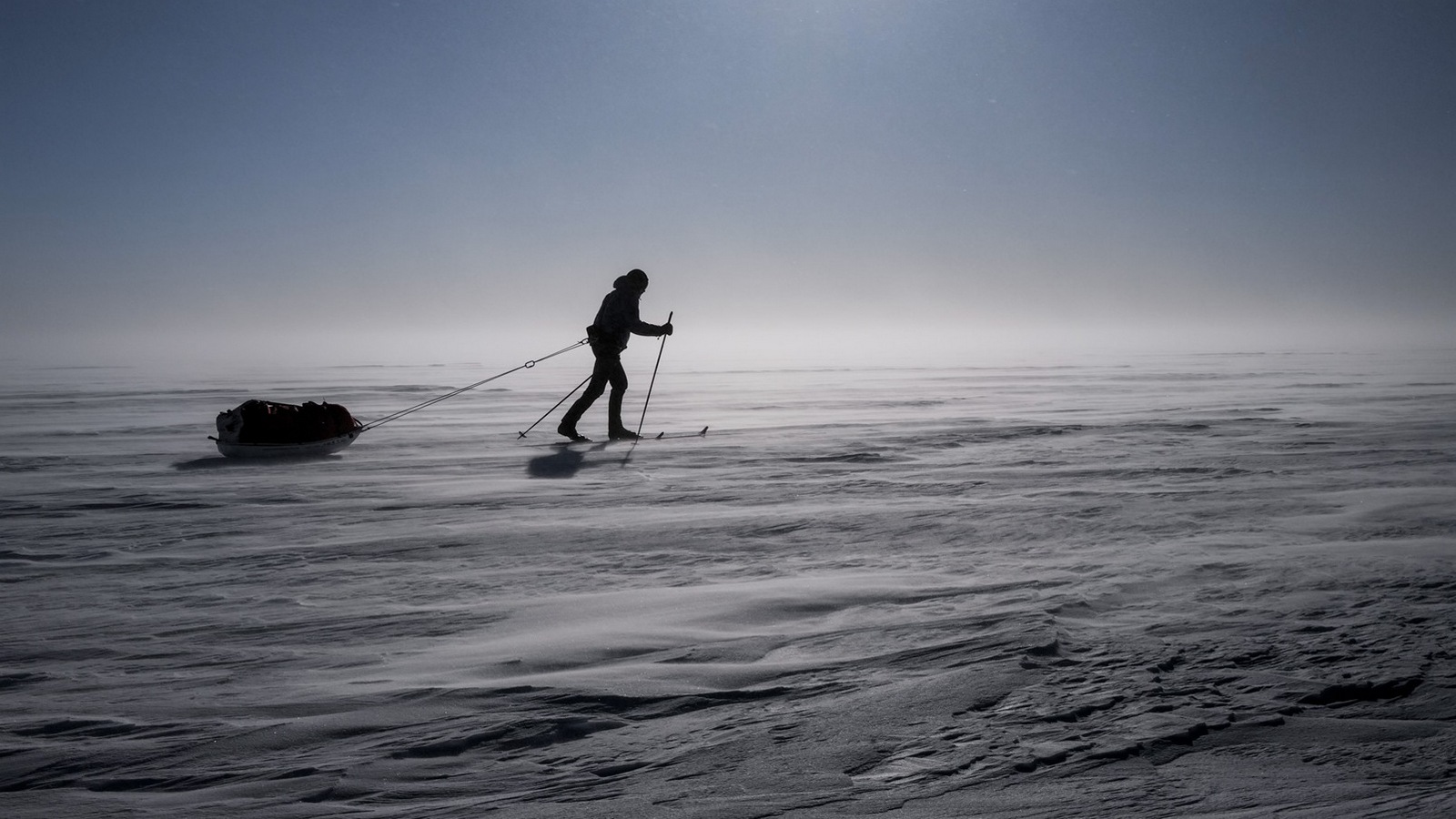
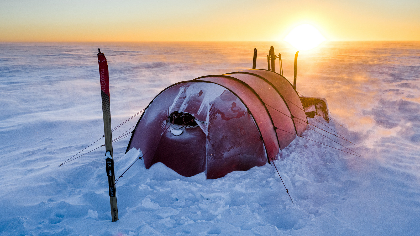
Greenland crossing: food for ultimate Arctic adventure
Food and drinking for Greenland Crossing adventure: a diet for 35 days expedition in Arctic.
The HRP – Haute Route Pyrénéenne, or Pyrenees High Level Route – has turned out to be a demanding and beautiful way. By demanding I mean it has forced some effort, although it hasn’t posed any extreme difficulties. It has been a satisfactory adventure. This text is a guide, an effect of my travel.
I have written it down having in mind those of you, who are thinking about thru-hike of the Pyrenees along HRP or visiting any part of these mountains in the subsequent seasons. Much of my advice concerns travelling the HRP, some of them will be useful also on other ways.
The HRP is a long-distance route, leading though the whole Pyrenees. However, the name “route” may be misleading – it is not marked from its beginning till the end with one colour. There are two routes leading through the chain of the Pyrenees: the French GR10 and the Spanish GR11, connecting the Atlantic Ocean and the Mediterranean Sea. However, each of them goes through the territory of one country only.
The HRP is not another, marked route. Sometimes it goes together with the two routes described above, yet it very often leads though smaller paths, minor routes (GR108, GRP7 and others) and it leads through unmarked land in the Central Pyrenees, where you navigate by small mounds. Don’t stick to one side of the border. You can go freely from France to Spain and Andorra and back. There are many versions of the route. In a way, the HRP is more of an idea than the route as such.
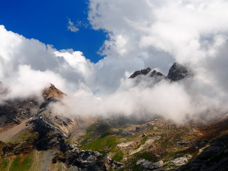
However, as a general rule, in the HRP you keep as close to the main ridge as possible. Whereas GR10 and GR11 regularly go down to the valleys and little towns, the HRP leads through the highest parts of the Pyrenees. It requires a great deal of independence, experience in high mountain area and exposure, the ability to climb big height differences and camp, to forecast the weather and carry quite significant supplies of food. You also need a good deal of experience, also in the high mountains, which are not forested. It is, probably, the most difficult trekking route in Europe, and if not – then it is one of the most difficult ones.
After all, the award for doing the HRP is 800 km through the high mountains, beautiful views, demanding and various terrains. After the 5 weeks on the route I think it is one of the most beautiful routes I have ever gone.
The starting point of the HRP is the beach in Hendaye, at the French-Spanish border, at the Atlantic. The end is the Mediterranean Sea coast in Banyuls-sur-Mer. Both of the places constitute also the ends of the French GR10 route. The whole HRP is about 800 km of hiking. The height difference sum on the route amounts to 42 000 metres, and according to GGPS measurement – 43 700 metres.
Time required to thru-hike the Pyrenees depends on your strength, physical condition, your backpack and weather. The Cicerone guide divides HRP into 45 one-day-stages. Some of them are short enough to connect and do two at one time. On the other hand – you shouldn’t rely on the time provided in the book. A stage described for 9-10 hours will take 12-13 hours, even when done by a skilful walker. Therefore, you need to be careful when considering the estimated time.
I have done my HRP with no support and it took me 34 days. It is a good result, doable for a experienced tourist, whose backpack is not too heavy. On my way I’ve met some long-distance walkers, who hiked faster than me. However, the HRP is not worth changing into a race. 40-42 days will be enough to cover the whole distance in a moderate pace, 45 – if you go more slowly, rest or climb the summits which are out of the route (e.g. Pico de Aneto).
I set off from Hendaye on 9th July and reached Banyuls on 11th August. Thanks to such a period the high passes were no obstacle. Even in the places, where snow lies the whole year, the snow was hard and passable even in hiking shoes. If you set off to the HRP earlier, you may encounter big snowfields. If you postpone your travel till September – you may meet early autumn storms and the first snow fall. July and August are the best time for the route.
If you land in Paris, you need to get to the railway station, from which there leaves the train to the west. If you want to reach Hendaye, head for Montparnasse railway station and get into TGV train going directly to Hendaye. You can buy your train ticket on-line. The return journey is a short ride by local train from Banyuls-sur-Mer to Perpignan, and then by TGV to Paris.
Due to historic reasons, the basic HRP guide should be the “Haute Randonèe Pyrènèene” written by the author of the route, Georges Véron. It is written in French and is popular mostly among the French hikers, although there is also an English translation. The second guide is “Pyrenean Haute Route” by Ton Joosten, published by Cicerone Books. The fact that it is written in English is its indisputable advantage and therefore it is chosen by almost all foreign tourists, who hike in the Pyrenees. The third guide consists of two volumes under the title: “Walks and climbs in the Pyrenees” by Cicerone Books, which contains the descriptions of trips in the Spanish Pyrenees and leads also through the middle part of the HRP between Lescun and El Serrat.

The routes described by Véron and Joosten differ. Also there are some differences between the two editions of Joosten’s guide from 2003 and 2009. However, having compared the route proposed by the two authors, I see that it goes through the same towns. The differences concern only small parts. I didn’t aim to walk the route considering strictly its “originality”. It sufficed, that it was close to the original version and led along the main ridge, so that I could enjoy it.
I used the Joosten guide and I recommend it. Mistakes and inaccuracies are seldom and they don’t influence the navigation. The descriptions are accurate and maps in the text are very useful. I happened to hear some critical opinions about the guide, however, I have an impression that they came from people who have navigated in accordance to Joosten’s tips and have forgotten to navigate by the terrain and work with their compass. During 34 days of my journey it happened to me once only, that I have lost the route, as a result of an inaccurate description combined with a badly marked path. It was near Refugio de Belagua, on a calcareous plateau devoid of water. The rest of the way didn’t pose nearly any difficulties, even in bad weather.
The set of maps covering the whole HRP contains 12 maps (the numbers of the maps are in brackets):
Such a set costs about 150 Euro. However, if you want to have a good map at your disposal at any time of your journey, it is worth to have such a set. If you prefer 1:25 000 maps, you might as well take a whole bookshop with you, and the cost of covering the whole HRP on such maps will reach 500 Euro.
How to get pyrenean maps cheaper?
First of all: you might do the HRP using only the maps from the guide. It is risky but possible. During 34 days of hiking I used the maps I carried only three times. I based my navigation on the maps from the book and the compass. However, if the weather this year had been worse – I think I would have liked to have good maps. You can do the HRP only with the guide, but you have to be sure you know what you are doing.
You can also use this webpage in Open Street Map where HRP route is divided into 41 day-long sections. Print your own maps in a requested scale or enter data from the webpage into your GPS device.
My solution was a compromise between safety and the price. I’ve bought four maps in 1:100 000 scale. They were less precise, but the total cost was 30 euro. Thanks to the guide I’ve hardly ever used them. The HRP requires some experience in navigation, but it is not difficult.
Most of the people start from the west to the east. A reverse route is also possible – it has no influence of the difficulty of the route.
Boots
Crossing the HRP was at the same time a test of Arc’teryx Bora 2 boots. The thru-hike in them gave me a lesson – hike in low-cut shoes! In the heat of the Pyrenees my feet, closed in Gore-Tex cocoon, have become chafed many, many times.
I’ve seen a few long distance hikers, who entered their HRP in light approach shoes or even trail shoes. Hiking in a difficult trail in shoes may seem a bad idea, but I can assure you, it is not. I would love to change the high boots into light approach shoes.
Clothes
Hot summer meant that had to protect myself against the sun more often than cold. At 2000 m the sun operates really strong. On chilly and rainy days a light set of clothes I’ve taken, was more than enough.
The basic set of my clothes consisted of a light polyester T-shirt and nylon pants. In cooler weather I have worn merino wool underwear. Additionally I’ve had 2 powerstrech layers for cold mornings and high altitude. When it comes to a waterproof layer: I’ve had a TNF Venture jacket and TNF Resolve pants.
I also had 3 pairs of trekking socks, a sunproof hat and a warm Windbloc cap.
What was missing? Definitely I could use a long-sleeved shirt, which would protect my arms against the sun. On my way through the Pyrenees, during the trekking from the west to the east, the right side of my body was constantly exposed to sunrays. For the first time I have experienced sunburns on my arms. For the hottest days I would also take a pair of shorts.
Backpack
I’ve used Thule 65 Guidepost backpack and that size was quite good for the HRP. It allowed me to carry all the gear and food for such a long time. Currently, having reduced my luggage, I would easily squize myself into my favourite Deuter ACT Lite 50+10.

Cooking
Buying gas in France can be a real pain in the ass. Starting the route in Hendaye I’ve spent 3 hours looking for gas which would fit my camping stove. Finally I have managed to find it in Bricomarche DIY store, where I have obtained a Campingaz CP 250 gas cylinder. In mountain resorts you can buy propane/butane gas cylinders (see below). My set comprised of an Optimus Crux Lite stove and a GSI Pinnacle Dualist pot.
Shelter
Camping in Pyrenees is allowed or at least tolerated and the exceptions are very rare. Also in national parks you can put up a tent, provided that:
It is worth to have your own shelter and to be independent from mountain hostels, which are expensive, or from refugios, which might be overcrowded.
In order to save some weight I‘ve taken to the Pyrenees a 400-g tarp, which can be stretched on two trekking poles. I successfully used it while thru-hiking Iranian Zagros range and now it proved to be perfect once again.
In the Pyrenees you will find some hostels, in which you may stay and/or have a meal. The price in such a place is usually about 15 euro for a night and 12-16 euro for lunch. Full board, that is three meals and accommodation, is about 45-50 euro. Therefore it’s better to consider such places only as an option. The hostels are located mainly in the central part of the chain, while in the sections Hendaye – Lescun (first 7-8 days) and Pic Carlit – Banyul (the last 4 days) they are rare.
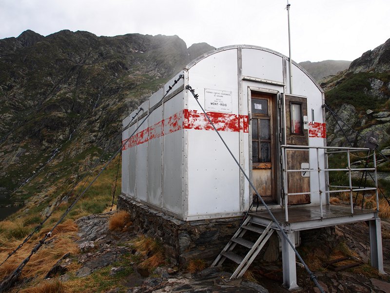
The Pyrenees have one thing that is missing in the Polish mountains: chalets and unmanned shelters, that is cabans and refugios. The chalets are sometimes occupied by shepherds, but some of them are seldom used or are not used at all, and they are made available to tourists to spend a night. Huts are modestly but sufficiently equipped. Sometimes you may find there a place to sleep and eat, sometimes even a fireplace.
In many places in the mountains you may find refugios, which are unmanned shelters. They are often situated at the banks of lakes. Inside you may find a few sleeping places, a table and a bench. Some of them are equipped with radio devices for potential rescue purposes. A few inhabitants suffice to raise the temperature inside, so despite the cramped conditions the refugium will usually pose a better solution than a tent. The best I remember, I passed in northern Andorra. Hundreds of shelters are listed on the extremely useful webpage pyrenees-refuges.com.
During thru-hike of HRP I’ve spent 3 nights in the so-called gite d’étapes, simple and cheap (10-15 euro) shelters in towns. You may order a lunch or full board there and take a warm shower. I used the ones in Lescun, Salardu and l’Hospitalet-près-l’Andorre.

Sleeping bag
Even in summer temperature at night might drop to 0°C and even in July it might snow in the Pyrenees. Expect the unexpected. A sleeping bag should give you the thermal comfort around 0°C and in case of lower temperature you may protect yourself with warmer clothes. I’ve also used my Ridgerest mat, however now I would choose lightweight inflated mattres instaed.
Crampons? Ice axe?
I have been advised to take crampons and an ice axe several times. My answer is: no. Even if there had been more snow than that season, for me no place was dangerous enough to even think about using this type of gear. The steepest and snowiest descent from Col Infériur de Literole required some more attention, but that’s all. Carrying additional 1-2 kg of steel at 800 km distance of 800 km is a generally a bad idea.
One situation is an exception: when you decide to depart for the HRP in low-cut shoes. In this case you might consider taking anti-slip mini-crampons for your shoes. I’ve seen one tourist who hiked the whole HRP in light trail shoes and used some of them, in the shape of metal springs. Trekking poles will be enough instead of an ice ace. They will be extremely useful during 5-6 weeks mountain route, full of descents and ascents.
Useful accessories
Navigation and marking
Big number of HRP’s sections goes along marked paths. Sometimes it just follows GR 10 and GR 11. More often they are local trails. All of them are marked with a symbol of white and red stripes (something like the flag of Poland). Signposts are regularly seen along.

On many passes, especially in the western part of the Pyrenees, you can find the signs of Camino de Santiago, the way of St. James, leading to Santiago de Compostela. They often cross the HRP and rarely go together.
In more remote regions the route might be marked with yellow stripes. Sometimes they resemble small strokes of paint on the rock. In the high parts of the Pyrenees, between Gavarnie and Andorra, you will regularly hike through places, where the path is almost invisible between the boulders and the direction is set by small cairns/stone stacks. You need to rely on your guide, map and observations in such places.
HRP is a difficult route in terms of its technical difficulties, not navigational ones, however. Although the rocky and wild terrain might be challenging, everyone who can navigate with a map and compass will find the way. Fog and rain may make it more difficult, but they don’t necessarily mean making you lost. And the descriptions in the guide are good enough to lead every experienced walker. Is a GPS device necessary? In my opinion, on HRP, definitely not.
Food and supplies in the HRP
Ton Joosten’s guide divides the Pyrenees into 5 stages. That division makes a lot of sense, because the end of each stage is a place, where you can find accommodation and replenish your supplies. During my Pyrenees thru-hike only once I had to take few kilometres to the side to get to a shop. Below you will find a list of all point where you can make some supplies. I provide you with the numbers of the days according to the guide. In reality I walked faster:
My menu for 34 days of hiking consisted mainly of a portion of muesli for breakfast, nuts, almonds, chocolate, cereal bars etc. as snacks during the day and a warm meal in the evening. During the first 8 days the warm meal meant buckwheat flakes with some sauce, during the rest of HRP thru-hike – couscous with some sauce and veggies and potato puree. I have supplemented protein with some canned fish and I took 0.5 litre of olive oil as an energy boost. Occasionally I traet myself with a warm meal in gite d’étape or bar. As usually during thru-hikes, I had some vitamins. Cooking one meal a day, I used around 500 grams of gas/34 days.

Water
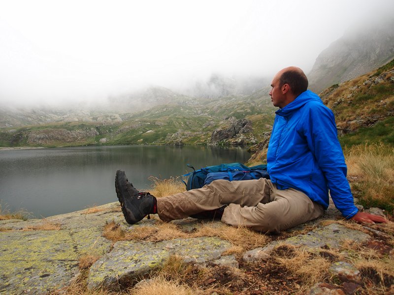
Only once I found myself in a place, where I had a serious problem with water. It was Llano Carreras plateau, a nasty and badly marked place, west from Lescun. It is a limestone, karst region, which means, that water soaks into porous rock and you won’t find any of it on the surface during many kilometres. The only tip: in the region of Refugio de Belagua take a lot of water (3 litres) and use it carefully, because next time you will find water will be close to Marmitou source, at the French side. I survived thanks to snow, that I luckily found under the ridge. Besides that water is abundant everywhere on HRP. It was very rare that I have had to carry more than 1.5 litre of water.
I’ve drunk water straight from the sources, uncooked and unfiltered. I have never had any stomach troubles, though I’ve inspected the place carefully, before I used it.
Animals and herding
Bears? Yes, they are. Reportedly, around twenty. So little chance you’ll meet one of them.
Shepherds’ dogs present a bigger danger, because herding is common in Pyrenees. You will meet signs and instructions, warning against the dogs and teaching how to behave in the presence of a herd of cows or a flock of sheep, guarded by a sheepdog. The dogs may be troublesome, but usually a trekking pole is enough to scare them off. Most of them passed me with no reaction. A general rule: don’t approach too close neither a dog, nor the herd. Also don’t go between the dog or the herd guarded by it.
Money
Oatmeal and couscous aren’t expensive. I’ve spent around 35-50 euro for a typical 6-day-shopping. Add the cost of 3-night-accommodation (12-15 euro each night), a few warm meals (6-12 euro) and fuel. My 5 weeks thru-hike of HRP costed around 330 EUR. The cost of my journey from Poland to southern France and back was another 250 EUR.
Language
French, Spanish, Basque on the west and Catalan in Andorra and eastern Pyrenees. Sounds gross, but in reality it is worth to know a few basic words, e.g. numerals ad names of food products, in French and Spanish. A lot of people speak English, so communication won’t be a problem.
Solo or with somebody?
It is not a sheer coincidence that all the people, I’ve met on the HRP, were hiking alone. This is the route for people who enjoy challenges, peace and solitude. There is something incredible in the feeling of uncertainty, which appears when you walk alone along difficult path – and the Pyrenees HRP is such a path. There are objective dangers, but experienced traveller will cope with them.
Obviously, there are teams doing the HRP. However, choosing the right person for such a route is a key. It is good, if you know each other from previous mountain adventures and know that you can rely on the other person even in difficult conditions.
If you are alone and you have an accident, remain calm and call help on the phone. If you can’t – wait patiently. There are little people in the Pyrenees, but it is not a desert. During the season, you can meet people every day. Sooner or later somebody will reach you.
Insurance
Rescue actions in France – despite what is often said by the insurers – are free of charge. The only case, when the rescuers can give you a bill is when you are a skier on a ski run or out of it. In the Spanish Pyrenees you will pay for a rescue mission only in Catalonia and only if the accident was caused by your recklessness, e.g. when you failed to obey the bans or signs. Incidents on the routes are covered by free rescue missions (I base on this source, dated summer 2015). Remember, however, that any further medical treatment and evacuation to your country may present significant cost.
Food and drinking for Greenland Crossing adventure: a diet for 35 days expedition in Arctic.
Greenland Crossing: walking over 600 km in Arctic desert, across the largest island in the world.
Greenland Crossing: walking over 600 km in Arctic desert, across the largest island in the world.

6 Responses
Hi, thanks for putting this up, I enjoyed reading your post as part of planning my HRP thruhike for 2020.
Do you remember which 1:100,000 exactly did you use?
Yes, of course. These were 4 maps from series “TOP100 Tourisme et decouverte”, as follows:
166 Bayonne
167 Pau / Tarbes
173 St-Gaudens/ Andorre
174 Beziers /Perpignan
Good luck!
Ł.
Thank you so much!
Thank you so much!
Lots of great advice. Will especially use your food plan! I’m leaving the 3rd of july from Hendaye with my girlfriend we will not be doing the Joosten guide but this one. https://whiteburnswanderings.wordpress.com/2018/12/28/hrp-pocket-guide-rev-1/
We are going UL so gonna be exciting! A link to my lighterpack if you wanna check it out. My GF will be taking the stove.
https://lighterpack.com/r/drsnpq
All the best,
Mads
Very interesting article. There are a lot of great tips there.
Can I ask – are there any via ferrata or exposed climbing?
Thank you
Preparing the HRP fully unsupported (all night in my tent + carry all my food and gear from the start so not buying any food underway)/ I hope to start on 21 July with a pack of +-45kgs and t should take 40-50 days.